The restriction of high-resolution satellite imagery over Iran following US administrative pressure exposes a fundamental friction between the commercial viability of "Space as a Service" and the sovereign requirements of National Security. This is not a simple case of censorship; it is the manifestation of Shutter Control, a legal and operational mechanism where the state asserts primacy over private data streams. To understand the implications for global intelligence parity, we must deconstruct the hierarchy of satellite governance and the technical dependencies that make "neutral" commercial observation an impossibility.
The Triad of Satellite Sovereignty
The ability of a private entity to provide imagery is governed by three distinct layers of control. When a provider restricts access to a specific geography, they are responding to one or more of these vectors: In related developments, take a look at: Artemis II Logistics and Risk Architecture Recovery Analysis of the First Lunar Flyby Since 1972.
- Regulatory Licensing (The Legal Kill-Switch): Under the Land Remote Sensing Policy Act and similar international frameworks, commercial operators function under licenses that explicitly allow the government to restrict data collection or distribution during periods of national security sensitivity.
- Financial Monopsony (The Anchor Tenant Effect): The US government, primarily through the National Reconnaissance Office (NRO) and the National Geospatial-Intelligence Agency (NGA), is often the largest single customer for high-resolution imagery. This creates a "soft power" dynamic where the provider cannot risk their primary revenue stream by defying the strategic interests of their main patron.
- Ground Station Dependency (The Physical Chokepoint): Satellite data must be downlinked to physical antennas. If these antennas reside on the soil of an allied nation, that nation maintains physical jurisdiction over the bits before they reach the cloud.
The Mechanics of Selective Blindness
Restricting imagery does not mean the satellite stops taking pictures. Instead, it involves the implementation of Geofenced Latency or Pixel Degradation.
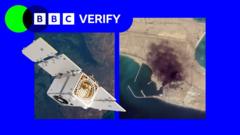
In the case of Iran, the "restriction" typically takes two forms. First, there is the suspension of "Direct Access" tasks, where third-party clients are barred from pointing the sensor at specific coordinates. Second, there is the "quarantine" of the archive, where historical data is removed from public-facing catalogs to prevent Open Source Intelligence (OSINT) analysts from performing Change Detection Analysis. MIT Technology Review has provided coverage on this critical topic in extensive detail.
Change Detection Analysis is the mathematical comparison of two images of the same location over time. By calculating the pixel-by-pixel variance, analysts can identify:
- Infrastructure expansion: The pouring of concrete for missile silos or enrichment facilities.
- Operational tempo: Changes in vehicle patterns at military bases.
- Post-kinetic assessment: Evaluating the success of a strike or sabotage event.
When a provider restricts these images, they are effectively breaking the "Temporal Chain" required for OSINT, granting the observed state a window of operational opacity.
The Asymmetry of Commercial vs Classified Intelligence
A common misconception is that restricting commercial imagery leaves a total void in surveillance. This ignores the Intelligence Stratification model.
- Classified Tiers: The US and its allies maintain "National Technical Means" (NTM)—classified satellites with resolutions and spectral capabilities (such as specific Synthetic Aperture Radar or Hyperspectral bands) far exceeding commercial offerings. These remain fully operational over restricted zones.
- Commercial Tiers: These serve as the "High-Volume, Low-Sensitivity" layer. They allow the state to offload routine monitoring to the private sector while reserving NTM for high-priority targets.
The restriction of commercial imagery is therefore not about blinding the US government; it is about blinding the unauthorized observer. This includes NGOs, journalists, and adversarial intelligence agencies that lack their own domestic satellite constellations. By removing the commercial layer, the US re-establishes an "Information Monopoly," ensuring that only entities with sovereign space programs can see what is happening on the ground.
The Economic Degradation of Data Trust
For the satellite provider, complying with political pressure introduces a significant Risk Premium to their business model. Global customers—particularly those in the Middle East or Southeast Asia—now view Western satellite providers as "Non-Neutral Utilities."
This creates a market vacuum that is being rapidly filled by non-Western competitors. We are seeing the rise of a "Bipolar Remote Sensing Market" where:
- Western Providers offer superior resolution and spectral diversity but carry high political risk for non-aligned nations.
- BRICS-aligned Providers (such as those from China or India) offer "Sovereignty-Neutral" data, promising that service will not be interrupted by US State Department mandates.
The long-term cost of restricting Iran imagery is the erosion of the US-led commercial space ecosystem's market share. When a commodity—in this case, 30cm-resolution pixels—becomes a tool of foreign policy, it ceases to be a reliable commodity for global trade.
Synthetic Aperture Radar (SAR) as the Technical Workaround
The restriction of optical imagery is increasingly bypassed by the proliferation of Synthetic Aperture Radar (SAR) satellites. Unlike optical sensors, which require sunlight and clear skies, SAR uses microwave pulses to "see" through clouds, smoke, and darkness.
$$\text{Resolution} \approx \frac{\lambda \cdot R}{2 \cdot L}$$
Where $\lambda$ is wavelength, $R$ is range, and $L$ is the synthetic aperture length. Because SAR is fundamentally a data-processing challenge rather than an optical lens challenge, it is harder to "shutter" effectively without disabling the entire platform. Many of the newer SAR constellations are operated by international consortia, making them less susceptible to the unilateral pressure of a single government.
The Strategic Path of Intelligence Democratization
The attempt to restrict imagery over Iran is a rear-guard action against an inevitable trend: the democratization of high-revisit surveillance. The "Secret-by-Default" era of geography has ended.
To maintain strategic advantage, nations can no longer rely on hiding physical assets. Instead, they must pivot toward Digital Obfuscation and Decoy Proliferation. Since the "Where" and "When" of an asset are now discoverable by any entity with a credit card and a non-Western data provider, the new frontier of security is the "What."
States must assume they are being watched 24/7. This necessitates a shift from denial of sight to denial of meaning. This involves:
- Multispectral Camouflage: Using materials that mimic the thermal and radar signatures of the surrounding environment.
- Underground Hardening: Moving critical nodes deep enough that even the highest-resolution commercial SAR cannot determine the internal configuration.
- Rapid Maneuver: Moving assets within the "Revisit Gap" (the time between one satellite pass and the next).
The restriction of Iranian imagery by a specific provider is a temporary friction in a global system moving toward total transparency. Organizations and states relying on "shutter control" as a primary security pillar are operating on an obsolete model of information scarcity. The strategic mandate now is to build resilience within a "Glass World" framework, where security is derived from complexity and redundancy rather than invisibility.